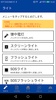

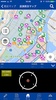


Enhance your emergency preparedness with the 中央区防災マップ, a multifaceted tool available in English, Chinese (Traditional and Simplified), and Korean. Access critical information on evacuation shelters and temporary housing for those unable to return home, along with a comprehensive disaster preparedness guide. Key features include a disaster map with route guidance and status updates, an offline map for use without an internet connection, and a safety confirmation function to communicate your well-being to family and friends during emergencies.
Stay informed with real-time transportation and infrastructure information, engage with educational disaster quizzes, and receive timely alerts on disaster-related news. The platform also offers downloadable guides for offline viewing and an SOS light signal feature. Users can leverage these resources to facilitate their safety and knowledge in times of crisis.
Please note, while the tool is free of charge, data usage costs for downloading and using it are the user's responsibility. The 中央区防災マップ is designed to be a reliable companion for community members, striving to ensure that everyone can navigate potentially hazardous situations with greater ease and security.
Requirements (Latest version)
- Android 8.0 or higher required
Comments
There are no opinions about 中央区防災マップ yet. Be the first! Comment